All Posts (680)

Sort by

New Using AutoCAD Civil 3D Point Groups Webinar

Webinar-Using-AutoCAD-Civil-3D-Point-Groups-179x300.png?width=179New Using AutoCAD Civil 3D Point Groups Webinar

Join Eric Colburn, PLS - The Geo+Business Innovator -ย for this intensiveย webinar on how to use AutoCAD Civil 3D Point Groups. This webinar explains how Point Groups work in AutoCAD Civil 3D and shows you effective strategies for drafting your surveying and engineering plans.

When:ย December 29, 2015 from 1:00 PM to 2:00 PM (EST)
Where:ย Online
Cost:ย $59custombutton?eid=18783810884&width=244

Specifically, in this webinar you will learn:

  • How to Create Point Groups
  • How to Edit Point Groups
  • Point
Read moreโ€ฆ
GEO Ambassador

On Being Prepared to Contribute

You'll Figure It Out

โ€œYouโ€™ll figure it out.โ€ The advice my mom gives has always been the same, whether addressing my high school homework or paying bills while taking a full course load in college. If I was looking for a shortcut, my mom was not going to be the one to provide it.

ย 

1198857640?profile=originalWhat do kids know, anyway? ย When I was a kid it infuriated the hell out of me, but what I then perceived to be a lack of understanding turned out to be an important keystone in my upbringing. As an adult, I realize th

Read moreโ€ฆ
GEO Ambassador

Introducing PhotoTag Android App for Land Surveyors

1198859212?profile=original

GeoTag Your Surveying Photos

We've highlighted mobile Android Apps for land surveyorsย in the past, but the app we are introducing today will knock your socks off! ย  Make way for PhotoTag, an app developed by our partners atย Surveying.orgย  for Android Devices which takes the pain out of attaching geolocations to your photos from the field!

ย 1198859307?profile=original

PhotoTag is not just an application for taking photos with Latitude, Longitude and Direction but adds addresses like those we use every day for giving direc

Read moreโ€ฆ
GEO Ambassador

The Story of Our Community Philosophy

Surveyor Community PhilosophyThis semester, I am taking a comprehensive advanced business plan writing course, in which I am writing the plan for the long awaited new platform for Land Surveyors United. ย As most of you know by now, my dad Skip Farrow passed away last June and because this network is something that we built together, I have been doing a lot of work on my own in attempts of getting the new site up and running. ย While doing so a lot of time has been spent digging up pages and archived information about the sit

Read moreโ€ฆ
Survey Legend
Arabic:
ุงู„ู…ุณุงุญูŠู† ู‡ุงู„ูˆูŠู† ุณุนูŠุฏุฉ!
Bosnian (Latin):
Sretan Halloween Geodeta!
Bulgarian:
ะงะตัั‚ะธั‚ ะฅะตะปะพัƒะธะฝ ะธะฝัะฟะตะบั‚ะพั€ะธ!
Catalan:
Inspectors feliรง Halloween!
Chinese Simplified:
ๆต‹้‡ๅธˆไธ‡ๅœฃ่Š‚ๅฟซไน!
Chinese Traditional:
ๆธฌ้‡ๅธซ่ฌ่–็ฏ€ๅฟซๆจ‚!
Czech:
Veselรฝ Halloween inspektory!
Dutch:
Happy Halloween landmeters!
English:
Happy Halloween Surveyors!
Estonian:
Happy Halloween รผlevaatajad!
Finnish:
Happy Halloween katsastajien!
French:
Happy Halloween arpenteurs !
German:
Happy Halloween-Vermesser!
Greek:
Read moreโ€ฆ
Vendor

YOU CAN TALK, JUST DONT STOP WORKING

This happened over 25 years ago but I still remember it.ย 

When I was an instrument man for a small surveying firm, I was new, young, and being trained by the party chief that had twenty years of field experience and was quite the outdoorsman. It was very hot outside, and we were way out in the county surveying a large tract of land. I had a good set up and the party chief was about 300 feet ahead of me with a prism pole. The rodman, who was also new on the job, had stayed back for whatever reason

Read moreโ€ฆ
Vendor

How to Save Money Surveying your Own Land

You've decided that you want to save money and survey your own land. Maybe you just bought a piece of land, or inherited your grandfathers farm, or maybe you've had a dispute with a neighbor and you want to survey your own land to know where the boundary line is located. The idea is a great one, you pick up a few pieces of surveying equipment, take some measurements and you just avoided all the expense of hiring a land surveyor. You have been told by your friends that land surveys are expensive

Read moreโ€ฆ
GEO Ambassador

Surveyors Share Their Day With Us on Facebook Too!

11745897_10206873069605967_5883067747016622349_n.jpg?oh=140b45c65494675094e1216fbfe0cc8f&oe=569A5C2F&width=200You may not know this, but our surveying community on Facebookย has over 11,000 followers, many contributing their surveying photosย with us from there. ย For example, take a look at this postย from this morning.

Surveyor Submitted Photos from around the globe on Land Surveyors United http://landsurveyorsunited.com/photo

Posted by Land Surveyors United onย Tuesday, July 7, 2015

Back in 2007 when we began Land Surveyors United network, we had no idea that one day we'd have the largest collec

Read moreโ€ฆ

Story of the 2 apprentices

Two apprentices were sent to measure a flag pole, and after trying to measure with tape, which bent and fell, trying to climb and sliding down and measuring the shadow but not knowing what to do with it, a salty old party chief noticed their dilema and ask what their problem was. The said they need to find out how high the pole was, the Chief grunted and retrieved a wrench from his truck, unbolted the pole, laid it down and measured it, 45 feet he exclaimed, and walked away, The two apprentices

Read moreโ€ฆ

Story of the 2 apprentices

Story of the 2 apprenticesTwo apprentices were sent to measure a flag pole, and after trying to measure with tape, which bent and fell, trying to climb and sliding down and measuring the shadow but not knowing what to do with it, a salty old party chief noticed their dilema and ask what their problem was. The said they need to find out how high the pole was, the Chief grunted and retrieved a wrench from his truck, unbolted the pole, laid it down and measured it, 45 feet he exclaimed, and walked away, The two apprentices

Read moreโ€ฆ

Following examples are calculated withย BestNetwork.

Free Station is also known as Resection. Get Location of the total station by measuring distance and angles to known points (back sights).

ย 

201507040652_edit.jpg

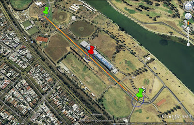
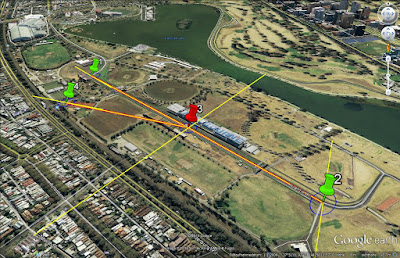
Free Station with 2 known points (back sights):ย 

- 1 new point (station) with unknown coordinates are marked in red (point 3).ย 

- Existing points with known coordinates are marked in green (points 1, 2).

- Station on point 3 with observations (orange lines) to point 2 and 3

ย 

201507040655_edit.jpg

Free Station with 3 known points (back

Read moreโ€ฆ

1198861807?profile=originalRegister, Learn and Earn 10% Towards LSU

Land Surveyors United is an awesome community, and I'm pleased to be able to give back to LSU with your help. Colburn Strategic Partners will donate 10% of every Geov8 Virtual Expo registration to LSU using this link, Click Here.

About Geov8

Geov8 2015 Virtual Expo is an online virtual geo+innovation event showcasing new and innovative geospatial technologies. Industry leaders and experts in geospatial tech will present cutting edge information and turnkey s

Read moreโ€ฆ

I was tired. Now I am retired.

1198862107?profile=originalNow that I am a retired surveyor I may spend more time thinking about my garden than thinking about surveying.ย  But I still find some topics interesting.ย  You may see a response from me once in a while if I think there is something I can add.ย  Mostly I will lurk because I do not ponder new technology.ย  New technology is for those who are still trying to scratch a living out of the dirt.

Read moreโ€ฆ

Log into community to no longer see ads

Land Surveying Guides

Our Blog Sitemap


Explore Surveying Locally

USA Surveying Forums
Asia Surveying Forums
Africa Surveying Forums
Middle East Surveying Forums
European Surveying Forums
South American Surveying Forums
Oceania Surveying Forums
Surveying Equipment Support Forums
Search Survey Photos
Add Posts, Surveying Photos, Videos and Articles to the Surveyor Community
Add Stuff to Community


Latest in Surveyor Community

Justin Farrowโ€™s photo was featured in Surveyors Online Toolbox
GlobeZilla User Guide
Welcome to GlobeZilla, an interactive tool that lets you project custom equirectangular maps onto a 3D globe, adjust settings like rotation speed, background, and size, and even create GIFs of your globe in action. This guideโ€ฆ
Wednesday
Justin Farrowโ€™s photo was featured in Surveyors Online Toolbox
ย 
Overview of the Historic Land Surveyor Locations from a Land Surveyor's Perspective
The Historic Land Surveyor Locations page provides an interactive map of significant landmarks related to surveying history across the world. By integratingโ€ฆ
Wednesday
Jennifer Reeder is now a member of Land Surveyors United - Surveying Education Community
Wednesday
Chris Wall and Sabinus Chinenye Ugwuanyi joined Land Surveyors United - Surveying Education Community
Land Surveyor Land Surveyor
Tuesday
Joshua Parker and Frederic Cann joined Land Surveyors United - Surveying Education Community
Land Surveyor Not a Surveyor
Sunday
Episode 235 - Dr. Tony Nettleman, Attorney, Educator, Author, Speaker & Mentor via GeoRadio- All Land Surveyor Podcasts in One

Such an interesting conversation! The guys were joined this week by the one and only Dr. Tony Nettleman. Tony is a Land Surveyor, Real Property Attorney, Author, Speaker, and Educator, who has been practicing for over 25 years. Dr. Nettlemanโ€ฆ

Sunday
Justin Farrowโ€™s discussion was featured in Continuing Education
Ethics courses, while commonly required as part of the Continuing Education (CE) for Professional Land Surveyors, differ in terms of the specific requirements, the number of hours, and how these courses are integrated into the overall CEโ€ฆ
Nov 12
Justin Farrow favorited Justin Farrow's discussion Exploring How US States Differences for Ethics in Continuing Education in Continuing Education
Nov 12
Moreโ€ฆ