- Community
- Community Blog
- Surveyor Community Blog
Dear All,
I am looking a good and big survey projects in india or outside of India..Having good capacity to execute...
Thanks
Vishal
Dear All,
I am looking a good and big survey projects in india or outside of India..Having good capacity to execute...
Thanks
Vishal
Just a quick note to let you all know that as we start to say goodbye to this old platform, I have added one last awesome feature to the network, which you can find on the home page. This should make it much simpler to post your burning questions, introductions and stories... Enjoy!
If you ever thought experience doesn't pay (and why would you?) you'd be wrong. Take a look at this graph. Entry-level workers have 0-2 years of work experience and require on-the-job supervision, while Fully Competent workers have many years of experience and require no supervision. You can learn a lot right here.
Sharing your experiences in surveying with the community ensures the steady salary climb.
Emplo
 New Using AutoCAD Civil 3D Point Groups Webinar
Join Eric Colburn, PLS - The Geo+Business Innovator - for this intensive webinar on how to use AutoCAD Civil 3D Point Groups. This webinar explains how Point Groups work in AutoCAD Civil 3D and shows you effective strategies for drafting your surveying and engineering plans.
When: December 29, 2015 from 1:00 PM to 2:00 PM (EST)
Where: Online
Cost: $59
Specifically, in this webinar you will learn:
“You’ll figure it out.” The advice my mom gives has always been the same, whether addressing my high school homework or paying bills while taking a full course load in college. If I was looking for a shortcut, my mom was not going to be the one to provide it.
What do kids know, anyway? When I was a kid it infuriated the hell out of me, but what I then perceived to be a lack of understanding turned out to be an important keystone in my upbringing. As an adult, I realize th
GeoTag Your Surveying Photos
We've highlighted mobile Android Apps for land surveyors in the past, but the app we are introducing today will knock your socks off! Make way for PhotoTag, an app developed by our partners at Surveying.org for Android Devices which takes the pain out of attaching geolocations to your photos from the field!
PhotoTag is not just an application for taking photos with Latitude, Longitude and Direction but adds addresses like those we use every day for giving direc
hi friends i need entry level surveyor job.
i have done my masters in geo-spatial science and technology from Indian institute of surveying & mapping, survey of India. so provide me small entry level job
This semester, I am taking a comprehensive advanced business plan writing course, in which I am writing the plan for the long awaited new platform for Land Surveyors United. As most of you know by now, my dad Skip Farrow passed away last June and because this network is something that we built together, I have been doing a lot of work on my own in attempts of getting the new site up and running. While doing so a lot of time has been spent digging up pages and archived information about the sit

Before working in Sangata - East Kalimantan - Indonesia
This happened over 25 years ago but I still remember it.
When I was an instrument man for a small surveying firm, I was new, young, and being trained by the party chief that had twenty years of field experience and was quite the outdoorsman. It was very hot outside, and we were way out in the county surveying a large tract of land. I had a good set up and the party chief was about 300 feet ahead of me with a prism pole. The rodman, who was also new on the job, had stayed back for whatever reason
You've decided that you want to save money and survey your own land. Maybe you just bought a piece of land, or inherited your grandfathers farm, or maybe you've had a dispute with a neighbor and you want to survey your own land to know where the boundary line is located. The idea is a great one, you pick up a few pieces of surveying equipment, take some measurements and you just avoided all the expense of hiring a land surveyor. You have been told by your friends that land surveys are expensive
 You may not know this, but our surveying community on Facebook has over 11,000 followers, many contributing their surveying photos with us from there. For example, take a look at this post from this morning.
Surveyor Submitted Photos from around the globe on Land Surveyors United http://landsurveyorsunited.com/photo
Posted by Land Surveyors United on Tuesday, July 7, 2015
Back in 2007 when we began Land Surveyors United network, we had no idea that one day we'd have the largest collec
Two apprentices were sent to measure a flag pole, and after trying to measure with tape, which bent and fell, trying to climb and sliding down and measuring the shadow but not knowing what to do with it, a salty old party chief noticed their dilema and ask what their problem was. The said they need to find out how high the pole was, the Chief grunted and retrieved a wrench from his truck, unbolted the pole, laid it down and measured it, 45 feet he exclaimed, and walked away, The two apprentices
Two apprentices were sent to measure a flag pole, and after trying to measure with tape, which bent and fell, trying to climb and sliding down and measuring the shadow but not knowing what to do with it, a salty old party chief noticed their dilema and ask what their problem was. The said they need to find out how high the pole was, the Chief grunted and retrieved a wrench from his truck, unbolted the pole, laid it down and measured it, 45 feet he exclaimed, and walked away, The two apprentices
Please have a look at the attached Newsletter. You can also download a free demo from www.ceaser.co.za.
CEASER stands for Civil Engineering And Surveying Earthworks Routines!
Following examples are calculated with BestNetwork.
Free Station is also known as Resection. Get Location of the total station by measuring distance and angles to known points (back sights).

Free Station with 2 known points (back sights):
- 1 new point (station) with unknown coordinates are marked in red (point 3).
- Existing points with known coordinates are marked in green (points 1, 2).
- Station on point 3 with observations (orange lines) to point 2 and 3
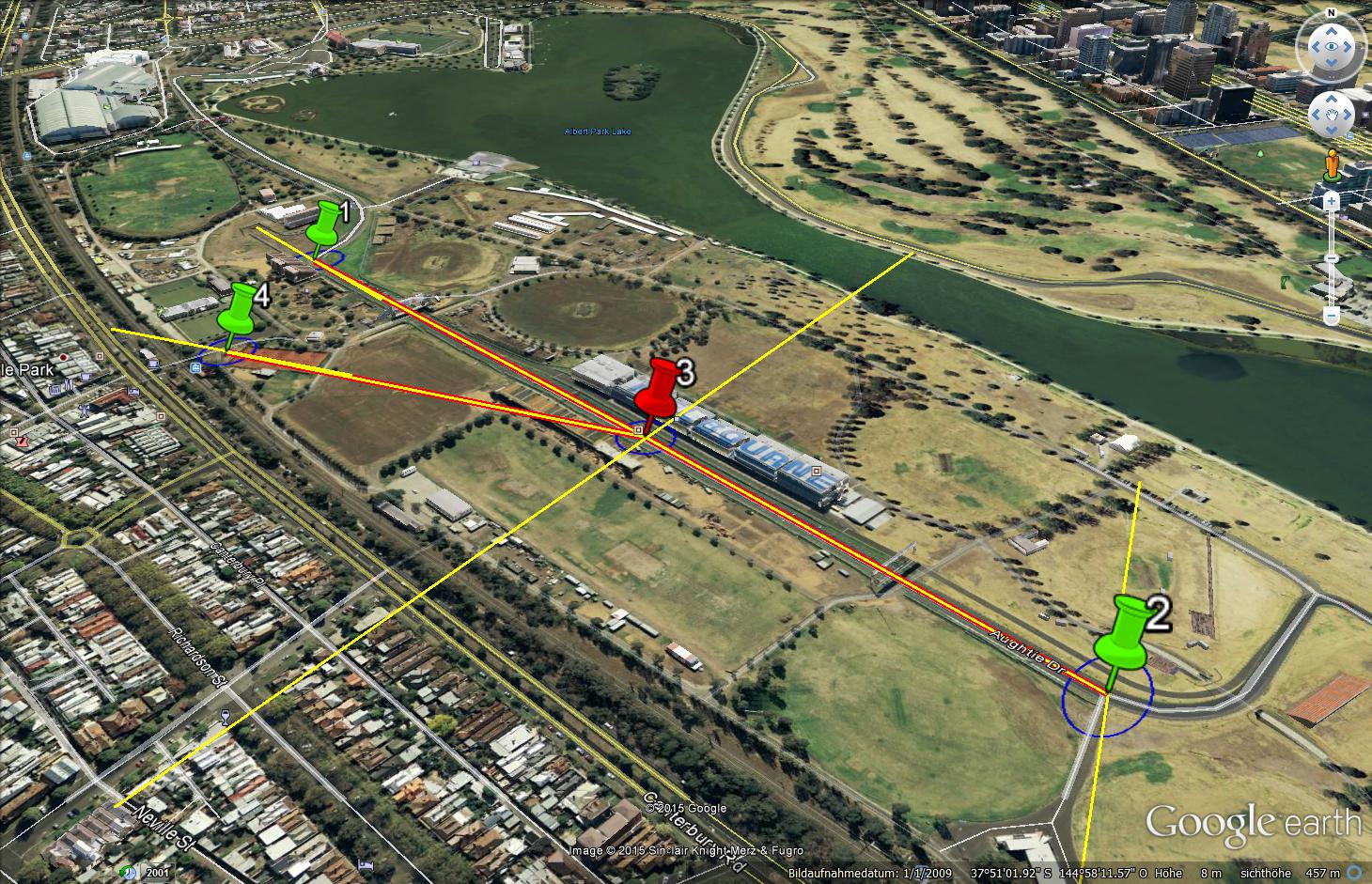
Free Station with 3 known points (back
Following up from the recent NSPS Student Competition, our latest episode of “Surveyor Says!” The NSPS Podcast features Joe Fenicle, Program Director/Assistant Professor - Surveying & Mapping Program at the University of Akron. NSPS Executive…