- Community
- Community Blog
- Surveyor Community Blog
pro
Survey data Co-coordinate-point export Excel to AutoCAD Download this Excel sheet Format and let me know what you think about it..
pro
Survey data Co-coordinate-point export Excel to AutoCAD Download this Excel sheet Format and let me know what you think about it..
Ok guys...this is the moment of truth. At Noon, where you are located, equipped with GPS/GNSS Equipment and having captured the data from your known point, here is where you log your data. We look forward to your submission.
Afterwards,please make the most of your submission by tweeting or sharing your participation using these five simple clicks...
Survey Earth in a Day 3D is a global surveying event, which is open for any professional specializing in the use of survey grade GNSS equipment, and/or the analysis of the resultant data. Our only requirement is that measurements be made with survey grade GNSS equipment at noon on June 21. In order to give us a rough idea of where everyone will be making GNSS observations, first, double click and find the location where you will be gathering GNSS data from @n
HELPING FOR SURVEYORS IN US IAM DOING FROM INDIA
I just figured out a couple of cool things about the new toolbar on the site and wanted to share these tricks with you all. Of course, you can always simply click any of the apps in the tool bar to open them, but if you'd like to collaborate with other surveyors viewing the same page, here are a few tips on how to do so.
How to open the Surveyor Chat Room from the Address Bar
Surveyor Chat Room App is launchable chat room which takes advantage of our integrated member system. This Chat Room featur
If we cannot think outside our local environment, we become chained to it. We are all chain-breaking for the Future on Land Surveyors United!
International Land Surveyors Week 2014 (June 15-22) is for Land Surveyors in any country on earth to celebrate the value of professional land surveyors in society. This is our 3rd year celebrating this week and it is slowly changing the industry into a more open and engagable situation for surveyors all around the world. Have you recently noticed all of
Social Media Isn't Scary
But it is specific. Support is seriously social. The following tweet from our newest member today Zee Madlala may turn out to be the doorway to success.
Any Surveyors in Africa who want to help a motivated student and fellow surveyor out?
@LandSurveyorsU I am a final year land surveying student looking for African land surveyors to assist me with my research.
— Zee Madlala (@zeepolar) June 10, 2014

When:
Thursday June 5
2:00pm - 3:00pm (EDT)
11:00am - 12:00pm (PDT)
Where: Online Webinar (Register Here)
This webinar will introduce DatuGram™3D, Datumate’s new innovative software for making geodetic measurements and drawing maps directly on images taken by regular camera. This cutting-edge technology, used on a daily basis by numerous surveyors worldwide, simplifies the Field-to-Plan process, making it faster, more cost effective, and
Just something interesting that was shared with me on Twitter.
Be careful out there Surveyors!
In view of recent developments in my family, the death of my brother, I wanted to write this article for all of those professionals (surveyors, engineers, attorneys, accountants, etc.) out there who are either sole proprietors, or one of two owners. Ultimately the article is about business succession, but I might wander a bit.
In Memory of Allen Maxwell, PLS
First, William “Allen” Maxwell was a Professional Land Surveyor in the State of Alabama, a fact he was very proud of. Allen started out l
Unable to find a satisfactory job and stuck in a job I hated I finally opened up my own Land Surveying Firm in mid 1992. I was 32 at the time and thought that I knew everything about Land Surveying because of my previous experiences. It goes to show you that arrogance is most often a result of ignorance.
As I look back now I realize that I had no idea at that time what I was doing and I am really uncertain at this point how I managed to survive in the beginning. After a couple of bumpy years howe
we are using PENTAX survey equipment in Sri Lanka.
I've been a member of Land Surveyors United since 2008 and I must say it has changed the way I survey, how I find information and how I learn. There are a lot of features on the platform which took me a while to find and understand and one of those is the Advanced Search page. Using this tool you can easily find other members on the network who use the same type of equipment you do. I've made this easy for you by running all of the searches and made them into simple links to click.
Find Memb
Following examples are calculated with BestTachySpot.
You may have experienced this before. You are defining a new station and all points with known coordinates are more or less in the same direction. Be careful in this situation.
The situation explained with an example:
Resection on point 1 with observations to known backsight points on the road north of the site (green in following figure). Goal is to find the coordinates of point 5.
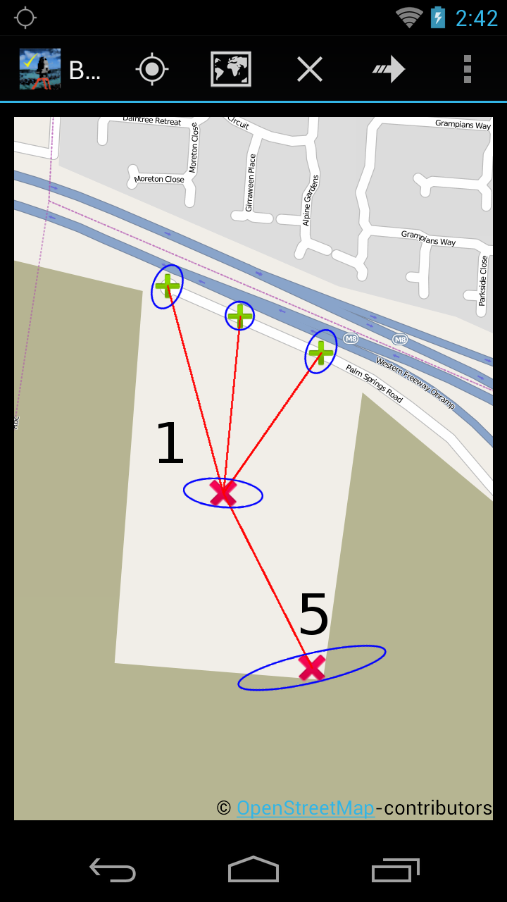

Accuracy (blue error ellipse in map):
Standard deviation is ver
THE NEW POB
The new point of beginning for land surveys is orbiting the earth at 5,000 miles an hour 12 ½ thousand miles up in the stratosphere. That’s correct and I suppose I owe my fellow professional land surveyors an apology for my participation in the changes we have been going through the last 20 years (see the POB cover article attached). The fact of the matter is the PLS’s of this country have had our exclusive provenances invaded by all manor of non-surveyor professionals and others.
There is a growing need for accurate land surveying data to be a fundamental requirement for government level geographic information systems. As an example for the USGS National flood inundation mapping science initiative a professional survey level data layer would be of great benefit to help determining exactly which structures in or out of the flood zones. Greetings my name is John W. Veatch. I am a land planner, a professional land development engineer, professional land surveyor, Florida Re
Why is "traverse 3" a good solution and "traverse 1" not? What is the difference in accuracy and reliability?
Following examples are calculated with BestNetwork.
Traverse is a method to establish control networks. Traverse networks involve placing survey stations along a line and then using the previously surveyed points with known coordinates as a base for observing the next point.
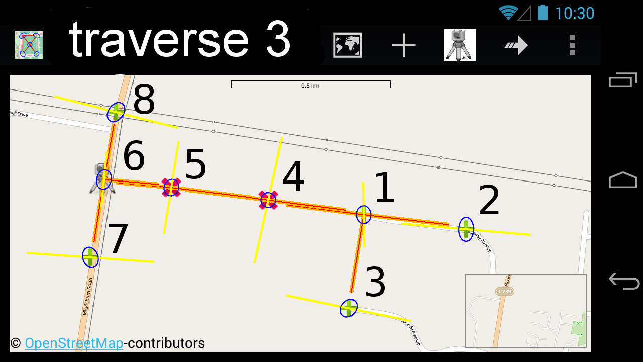
Traverse 3 explained:
- 2 new points with unknown coordinates are marked in red (points 4, 5).
- Existing points wit
Surveying
i am a surveyor ,i love survey because so many journeys......so many connections ...every day visiting new place,contacting new people,watching new culture..........etc....... ma ambition is improving my knowledge in diffrent type of surveys and new technologies......i will do it frnds .i will do it.
Over 75 recipes to help you automate geoprocessing
tasks, create solutions, and solve problems
for ArcGIS with Python
In the spirit of welcoming the new year, we are liquidating many items from the store to make room for new stuff! My son Justin has been helping me get the store in order and putting a fresh face on ePalmetto. As you can see in our recent post for January Survey equipment Liquidation, there are many items on sale that you might like to grab while you can..
Here is a short list of equipment we are selling from the closet:
(3) B-1 Levels
(1)SDR33 Data Collector
(1)Sa
Wow...that's all we can say about this episode. The guys were joined this week by Mr. Howard Buford. Howard has more wisdom in his little finger than DD & PS combined! Born in 1921, Fought in WW2 at the Battle of the Bulge, Practiced Land…
Our final episode in our series featuring chats with FIG Young Surveyors from the recent FIG Working Week 2024 in Accra, Ghana is Angela Anykora from Nigeria and Roshni Sharma from Australia. They joined Tim Burch to chat about the Working Week…