Why is "traverse 3" a good solution and "traverse 1" not? What is the difference in accuracy and reliability?
Following examples are calculated with BestNetwork.
Traverse is a method to establish control networks. Traverse networks involve placing survey stations along a line and then using the previously surveyed points with known coordinates as a base for observing the next point.
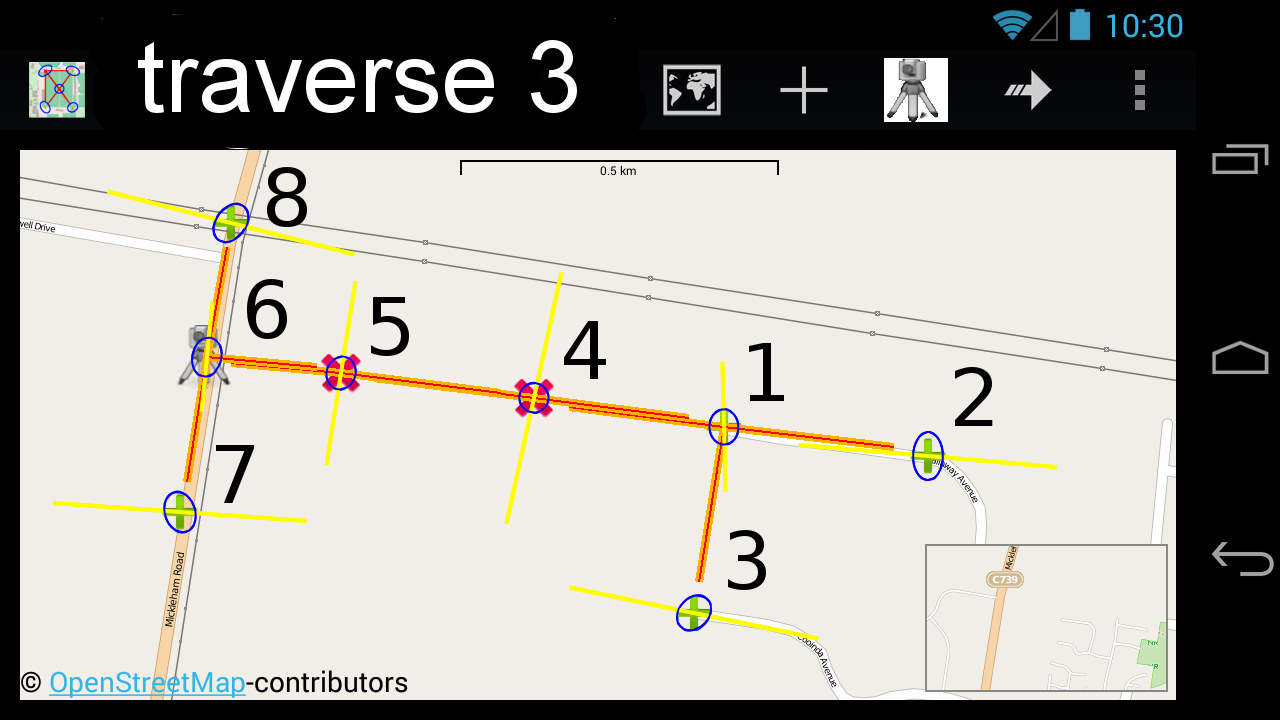
Traverse 3 explained:
- 2 new points with unknown coordinates are marked in red (points 4, 5).
- Existing points with known coordinates are marked in green (points 1, 2, 3, 6, 7 ,8).
- Station on point 1 with observations (orange lines) to point 2, 3 and 4
- Station on point 4 with observations to point 1 and 5
- Station on point 5 with observations to point 4 and 6
- Station on point 6 with observations to point 7,8 and 5

Traverse 1 explained:
- 2 new points with unknown coordinates are marked in red (points 4, 5).
- Existing points with known coordinates are marked in green (points 1, 2, 3).
- Station on point 1 with observations (orange lines) to point 2,3 and 4
- Station on point 4 with observations to point 1 and 5
Most critical point is number 5. Let's see the numerical result of traverse 1.

Accuracy (blue error ellipse in map):
Standard deviation in x is large. (notice that standard deviation of known points is set to 35mm)
Reliability (yellow line in map):
The report shows that the coordinates of point number 5 are not reliable. It is defined through the observation from station 4 and not controlled through any other measurements. A false observation from station 1 to target number 4 can cause an infinite wrong position of point 5 (999999 = infinite)
Add station 5 to traverse 1. What result can we expect whit this additional effort?

Traverse 2 explained:
- 2 new points with unknown coordinates are marked in red (points 4, 5).
- Green points are existing points with known coordinates (points 1, 2, 3, 6).
- Station on point 1 with observations (orange lines) to point 2, 3 and 4
- Station on point 4 with observations to point 1 and 5
- Station on point 5 with observations to point 4 and 6

Accuracy (blue error ellipse in map):
Standard deviation in x is quite good with 26 mm. (notice that standard deviation of known points is set to 35mm)
Reliability (yellow line in map):
The report shows that the coordinates of point number 5 are not reliable. A false observation (or in this case wrong angle) from station 5 to target number 6 can cause a position error of 270 mm.
Finally see the result of traverse 3. It takes a bit more time to measure all 4 stations. Is this effort worth it?

Accuracy (blue error ellipse in map):
Standard deviation in x is good with 16 mm. (notice that standard deviation of known points is set to 35mm)
Reliability (yellow line in map):
The report shows that the coordinates of point number 5 are reliable. A false observation (or in this case false angle) from station 5 to target number 6 can cause a position error of 93 mm.
Decide yourself!
- Traverse 1 is clearly a bad solution as the resulting coordinates of point 5 are not controlled in any way.
- Traverse 2 might be an option.There is some control and depending on the situation this may or may not be enough.
- Traverse 3 results are good in terms of accuracy and reliability of point 5 coordinates but it takes time to measure all 4 stations.
Check your own network design with BestNetwork.
Thoughts