Show us why the public should always call a land surveyor

Where are you surveying?


🌐 Show Forums for All Locations
Land Surveyor Community

Survey Legend

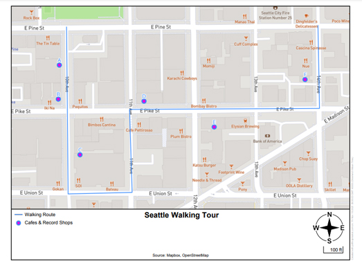
This morning I created a printable map of a short Seattle walking route, taking in some of my favorite record shops and cafes.

I created the map using the excellent PDF Map Maker.Which means my map is now a handy PDF file, which I can e-mail to my friends, and which we can all print-out whenever we want to use it. 

PDF Map Maker is a handy tool for making PDF maps. The creation tools allows you to make maps using any of 9 different base map styles (including road maps, satellite, and light & dark styles). To create a PDF map all you have to do is zoom-in on the area you wish to map and press the 'Download Map' button. The PDF Map Maker will then create a PDF Map of the area you selected. It is that simple.

You can also add features to your map if your want. For example in my Seattle Walking Tour map I have added a route line and 6 lettered points (indicating the locations of record shops and cafes along the route). To add lines, points or polygons to your map you just need to upload a GeoJSON file containing your geographical data to PDF Map Maker.

To create my Seattle Walking Tour PDF map I used the online Vector GeoJSON creation tool to create a GeoJSON file of 6 points (showing record shops & cafes) in Seattle. I then used geojson.io to create the GeoJSON file for the walking route line.It was then just a simple matter of uploading the two GeoJSON files into the PDF Map Maker.


Source: Maps Mania

You need to be a member of Land Surveyors United - Global Surveying Community to add thoughts!

Join Land Surveyors United - Global Surveying Community

Votes: 0
Email me when people reply –

Answer As your Facebook Page

Global Surveyor Forum

Latest Discussions by Category

How to Utilize Surveyor Forums

How to use Forums
Our forums on Land Surveyors United are here to be used as much for finding help with problems in the field as the are for you to express your opinions on anything that has to do with land surveying in general. Feel free to share anything that is on your mind, as long as it isn't meant to damage another member's reputation. Please keep it clean and help insure that everyone has the opportunity to enjoy the benefits of being part of a community that grows together.

We are committed to allowing freedom of expression for all of our members, and that includes maintaining a safe space for people with opposing views to express themselves. We get posts from all over the country and even the globe, so needless to say, people come with different viewpoints on lad surveying practices and processes. We see this diversity and variety as a real strength-- dialogue and debate are an integral part of the educational process, as well as an important tool in exploring different sides of complex issues.

All Community Hubs inside the community have their own forum for asking specific questions to other surveyors, by location, equipment type, etc.

Topics by Tags

Monthly Archives

Global Forums

Add Your Expertise

🌐 Explore Forums Based on Location

Blog Topics by Tags

Monthly Archives