Hello Surveyors,
I've just join this network group, and want to introduce myself.
I'm independent software developer and found some small company name SkyRaster.
I involved in creating of software for road construction (mostly road laboratories) and surveying (gps\gis\geodesy). My interests concern also 3D technology and the creation of tools for photogrammetric 3D reconstruction where I have a strong of experience (Master thesis about custom photogrammetric reconstruction systems (link pdf) that concern creation of tool like 3D Studio for 3D reconstruction).
Some years ago (2009) I develop some applications for geodesy (GPS surveying) for control of agricultural areas- TrackLab Manager as stand-alone application and Windows Mobile version - TrackLab Terminal. Application allows to do the linear measurements with use of built-in GPS.
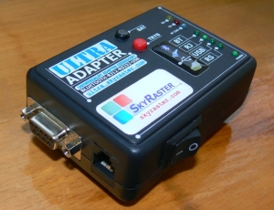 After that i've started Ultra Adapter project, which allow to get RS232 signal and convert it into the Bluetooth transmission. So when you have equipment with RS232 and want to use in with modern software (with bluetooth) - you can do it wihout changing the measurement hardware.
Last years I've interested in creation of universal surveying platform, that can be used with precision GPS (RTK) and surveying equipment like distance meters (Disto) and total stations - not only for geodesy but also for measurements inside buildings (plan measurement). With support for open spatial systems like OpenStreetMap.
 This year comes with finish some of that work. I've just finished application for creating GNSS reports from the RTK measurements (support for RW5[Carlson], RAW[Fieldgenius], CSV/DB [Landstar], XML [Leica], TSJ/MJF [Topcon]).
Also i'm just finishing application for RTK measurements directly from Android device (Bluetooth connection with RTK) and last day i've achieved another goal: the possibility to create GNSS raports from survey made on my RTK Android software.
This software has support for some of local coordinate systems, local geoids files and bring some calculations (COGO) like linear intersections, orthogonal offsets, intersections by 4-pt and many others. Of course one can also do the stakeout session. You can simply connect the Disto rangefinders (like A6, D8 or D3aBT) or Bosch (GLM100C) and do the linear intersection fast.
So I concern is it worth to create local (english) version of this app and target it to your local markets?
kind regards!
Mark Kupaj
SkyRaster owner & developer
Replies
cool... looks promising!