- Community
- Community Blog
- Surveyor Community Blog
Please have a look at the attached Newsletter. You can also download a free demo from www.ceaser.co.za.
CEASER stands for Civil Engineering And Surveying Earthworks Routines!
Please have a look at the attached Newsletter. You can also download a free demo from www.ceaser.co.za.
CEASER stands for Civil Engineering And Surveying Earthworks Routines!
Following examples are calculated with BestNetwork.
Free Station is also known as Resection. Get Location of the total station by measuring distance and angles to known points (back sights).

Free Station with 2 known points (back sights):
- 1 new point (station) with unknown coordinates are marked in red (point 3).
- Existing points with known coordinates are marked in green (points 1, 2).
- Station on point 3 with observations (orange lines) to point 2 and 3
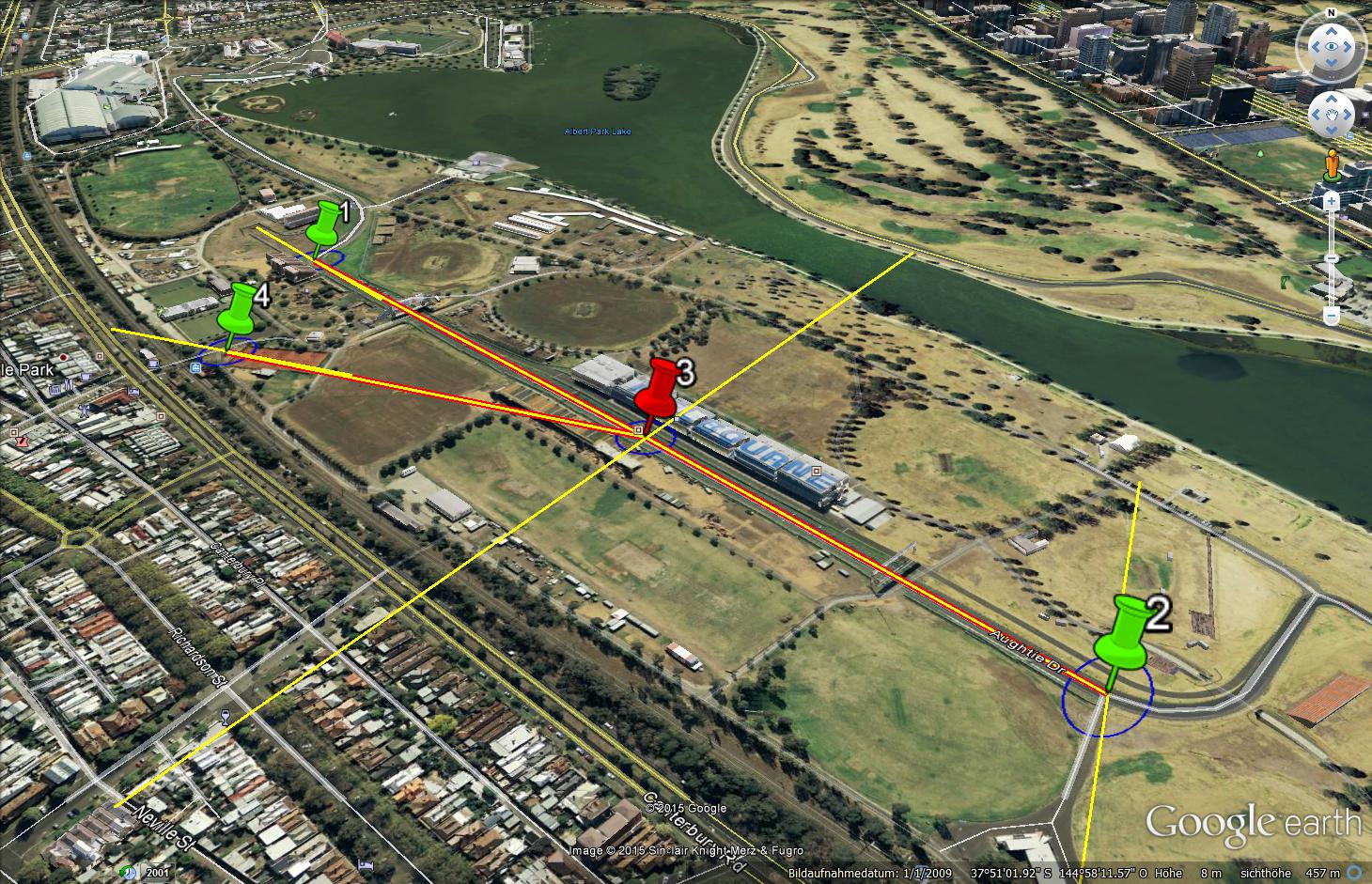
Free Station with 3 known points (back
Register, Learn and Earn 10% Towards LSU
Land Surveyors United is an awesome community, and I'm pleased to be able to give back to LSU with your help. Colburn Strategic Partners will donate 10% of every Geov8 Virtual Expo registration to LSU using this link, Click Here.
About Geov8
Geov8 2015 Virtual Expo is an online virtual geo+innovation event showcasing new and innovative geospatial technologies. Industry leaders and experts in geospatial tech will present cutting edge information and turnkey s
Hello,
I am Azman Arefeen, a Permanent Resident of Australia. Recently, I completed my Certificate 3 in Surveying and Spatial Information Services from TAFE Ultimo. I am looking for an Apprenticeship/ Traineeship while I do my Diploma. If someone can help me, it would really mean a lot for me.
Now that I am a retired surveyor I may spend more time thinking about my garden than thinking about surveying. But I still find some topics interesting. You may see a response from me once in a while if I think there is something I can add. Mostly I will lurk because I do not ponder new technology. New technology is for those who are still trying to scratch a living out of the dirt.
Hi All
There is a major upgrade on the Mobile Surveying Program for Windows Mobile Handheld Units, which can be downloaded for free at www.ceaser.co.za.
Regards
Michael
UPDATE: Please Share with Your Fellow #Surveyors
SURVEY EARTH IN A DAY 5 RSVP here:https://www.facebook.com/events/782567225208901/
June 21st @ Noon
Set Up GPS on Known Point
Submit location data
Help remeasure entire
surface of Earth
in a single day
#SEIAD5
surveyearth.com
Honored to see Survey Earth in a Day 4D featured this week on GPS World Magazine cover!
Things are starting to ramp up with less than 20 days to go until the big event!
If you haven't yet RSVPed to take part in
Here are a couple of articles published today that may be of interest and I encourage you to share links that you have stumbled across in the comments below.
Land Surveying Transforms Along with Technology
And other interesting state-of-tech article:
As the largest community body of land surveyors anywhere in the world with close to 9000 members, we have a responsibility. We must do all that we can to educate the public regarding our importance to society in order to pave the way for those who come after us. One way to accomplish this would be for each of us to record a short PSA sharing the nature of surveying jobs in the places where we live.
For Example, this PSA was submitted by Kennedy Komla of Ghana
For those who do not know, PS
Click the link to read about the efforts of my company to handle an intricate survey in a delicate environment.
Surveying in an Inhospitable Environment: Grassy Lake, Arkansas
The text from the link is as follows:
Low lying and delicate wetlands persist throughout much of southeastern Arkansas, yet drain tiles and clear cutting has greatly impacted the ecology of these areas making them very susceptible to drought. One such location is

Graham Ellis, Associate Director at the Royal Institution of Chartered Surveyors (RICS), presented athe recent INNSA, and giving land surveyors a good wrap... well done..
Here we are busy giving training on CEASER and the use of UAV's for Aerial Surveys, which was very successful.
For a free demo of the CEASER program visit www.ceaser.co.za. All processing of the Aerial data is done by using Photoscan from Agisoft.
See attached. Visit our site at www.ceaser.co.za.
Thanks Michael
If we cannot think outside our local environment, we become chained to it. We are all chain-breaking for the Future on Land Surveyors United!
UPDATE: NOW You can RSVP for International Surveyors Week 2015
Check out Importance of Community
by Justin Bradley Farrow at Mode
International Land Surveyors Week 2015 (June 14-21) is for Land Surveyors in any country on earth to celebrate the value of professional land surveyors in society. This is our 3rd year celebrating this week and it is slowly changi
I was checking out Vine earlier today thinking of a few ways to integrate social media outside of Land Surveyors United into the day and found some pretty cool short videos of land surveyors doing what they do best and figured I would try to embed a few as a test in the site. Turn the sound on to hear what they are saying in each.
Gotta Love Mosquitos at Work
Topo in the Park Baby!
3 Man Crew Day... I'm Sleepin'
Illegals Crossing the border
What He
Surveyor calc
I am a surveyor and I spent a lot of time to do surveys with my dad. Then I asked myself, why not speed things up? we have many daily electronic tools, why not use them?
That's why I decided to develop Surveyor calc.
Surveyor calc is an application designed to perform the max speed and productivity in the field of
survey.
It allows to calculate areas of a survey but also to create automatically a digital figure of the survey
to open in a CAD software.
Why this is a very useful app? This
UPDATE:
Happy National Surveyors Week 2018 Everyone!
The purpose of Surveyors Week (NSPS) is to bring visibility to the profession. During Surveyors Week, land surveyors across the nation celebrate by educating the public on what they do & why it is important; encouraging students to consider surveying as a career choice; and participating in activities that promote and bring awareness to the surveying profession. All licensees, governmental agencies, technical professional organizations and
"Surveyor Says! The NSPS Podcast" is all about connecting the past, present, and future, so this episode is no exception. Our guest this week is Carl Bert, PLS, a Pennsylvania surveyor who is looking to give back to the profession through…