- Community
- Community Blog
- Surveyor Community Blog
Before working in Sangata - East Kalimantan - Indonesia
Before working in Sangata - East Kalimantan - Indonesia
This happened over 25 years ago but I still remember it.
When I was an instrument man for a small surveying firm, I was new, young, and being trained by the party chief that had twenty years of field experience and was quite the outdoorsman. It was very hot outside, and we were way out in the county surveying a large tract of land. I had a good set up and the party chief was about 300 feet ahead of me with a prism pole. The rodman, who was also new on the job, had stayed back for whatever reason
You've decided that you want to save money and survey your own land. Maybe you just bought a piece of land, or inherited your grandfathers farm, or maybe you've had a dispute with a neighbor and you want to survey your own land to know where the boundary line is located. The idea is a great one, you pick up a few pieces of surveying equipment, take some measurements and you just avoided all the expense of hiring a land surveyor. You have been told by your friends that land surveys are expensive
 You may not know this, but our surveying community on Facebook has over 11,000 followers, many contributing their surveying photos with us from there. For example, take a look at this post from this morning.
Surveyor Submitted Photos from around the globe on Land Surveyors United http://landsurveyorsunited.com/photo
Posted by Land Surveyors United on Tuesday, July 7, 2015
Back in 2007 when we began Land Surveyors United network, we had no idea that one day we'd have the largest collec
Two apprentices were sent to measure a flag pole, and after trying to measure with tape, which bent and fell, trying to climb and sliding down and measuring the shadow but not knowing what to do with it, a salty old party chief noticed their dilema and ask what their problem was. The said they need to find out how high the pole was, the Chief grunted and retrieved a wrench from his truck, unbolted the pole, laid it down and measured it, 45 feet he exclaimed, and walked away, The two apprentices
Two apprentices were sent to measure a flag pole, and after trying to measure with tape, which bent and fell, trying to climb and sliding down and measuring the shadow but not knowing what to do with it, a salty old party chief noticed their dilema and ask what their problem was. The said they need to find out how high the pole was, the Chief grunted and retrieved a wrench from his truck, unbolted the pole, laid it down and measured it, 45 feet he exclaimed, and walked away, The two apprentices
Please have a look at the attached Newsletter. You can also download a free demo from www.ceaser.co.za.
CEASER stands for Civil Engineering And Surveying Earthworks Routines!
Following examples are calculated with BestNetwork.
Free Station is also known as Resection. Get Location of the total station by measuring distance and angles to known points (back sights).

Free Station with 2 known points (back sights):
- 1 new point (station) with unknown coordinates are marked in red (point 3).
- Existing points with known coordinates are marked in green (points 1, 2).
- Station on point 3 with observations (orange lines) to point 2 and 3
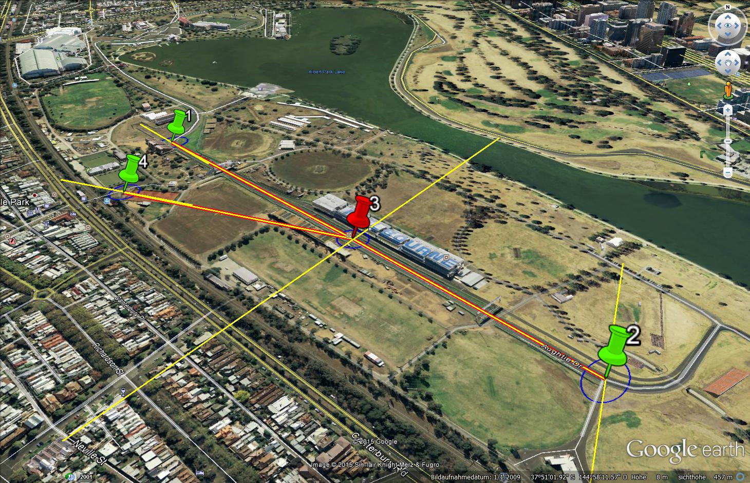
Free Station with 3 known points (back
Register, Learn and Earn 10% Towards LSU
Land Surveyors United is an awesome community, and I'm pleased to be able to give back to LSU with your help. Colburn Strategic Partners will donate 10% of every Geov8 Virtual Expo registration to LSU using this link, Click Here.
About Geov8
Geov8 2015 Virtual Expo is an online virtual geo+innovation event showcasing new and innovative geospatial technologies. Industry leaders and experts in geospatial tech will present cutting edge information and turnkey s
Hello,
I am Azman Arefeen, a Permanent Resident of Australia. Recently, I completed my Certificate 3 in Surveying and Spatial Information Services from TAFE Ultimo. I am looking for an Apprenticeship/ Traineeship while I do my Diploma. If someone can help me, it would really mean a lot for me.
Now that I am a retired surveyor I may spend more time thinking about my garden than thinking about surveying. But I still find some topics interesting. You may see a response from me once in a while if I think there is something I can add. Mostly I will lurk because I do not ponder new technology. New technology is for those who are still trying to scratch a living out of the dirt.
Hi All
There is a major upgrade on the Mobile Surveying Program for Windows Mobile Handheld Units, which can be downloaded for free at www.ceaser.co.za.
Regards
Michael
UPDATE: Please Share with Your Fellow #Surveyors
SURVEY EARTH IN A DAY 5 RSVP here:https://www.facebook.com/events/782567225208901/
June 21st @ Noon
Set Up GPS on Known Point
Submit location data
Help remeasure entire
surface of Earth
in a single day
#SEIAD5
surveyearth.com
Honored to see Survey Earth in a Day 4D featured this week on GPS World Magazine cover!
Things are starting to ramp up with less than 20 days to go until the big event!
If you haven't yet RSVPed to take part in
Here are a couple of articles published today that may be of interest and I encourage you to share links that you have stumbled across in the comments below.
Land Surveying Transforms Along with Technology
And other interesting state-of-tech article:
As the largest community body of land surveyors anywhere in the world with close to 9000 members, we have a responsibility. We must do all that we can to educate the public regarding our importance to society in order to pave the way for those who come after us. One way to accomplish this would be for each of us to record a short PSA sharing the nature of surveying jobs in the places where we live.
For Example, this PSA was submitted by Kennedy Komla of Ghana
For those who do not know, PS
Click the link to read about the efforts of my company to handle an intricate survey in a delicate environment.
Surveying in an Inhospitable Environment: Grassy Lake, Arkansas
The text from the link is as follows:
Low lying and delicate wetlands persist throughout much of southeastern Arkansas, yet drain tiles and clear cutting has greatly impacted the ecology of these areas making them very susceptible to drought. One such location is

Graham Ellis, Associate Director at the Royal Institution of Chartered Surveyors (RICS), presented athe recent INNSA, and giving land surveyors a good wrap... well done..
Here we are busy giving training on CEASER and the use of UAV's for Aerial Surveys, which was very successful.
For a free demo of the CEASER program visit www.ceaser.co.za. All processing of the Aerial data is done by using Photoscan from Agisoft.
This week’s “Surveyor Says! The NSPS Podcast” is chockful of governmental affairs updates! With the recent events within the courts of Texas and our nation’s Supreme Court, NSPS Executive Director Tim Burch caught up with our Legislative…