All Posts (3)

Sort by

The geometry of resections matters!

Following examples are calculated with BestTachySpot.


You may have experienced this before. You are defining a new station and all points with known coordinates are more or less in the same direction. Be careful in this situation.

The situation explained with an example: 

Resection on point 1 with observations to known backsight points on the road north of the site (green in following figure). Goal is to find the coordinates of point 5.

proxy?url=http%3A%2F%2F2.bp.blogspot.com%2F-3kBC4obs0uI%2FUwbBcItr7KI%2FAAAAAAAABKQ%2FJBS_ngwp9Kw%2Fs1600%2Fdevice-2014-02-21-134256.png&container=blogger&gadget=a&rewriteMime=image%2F*proxy?url=http%3A%2F%2F3.bp.blogspot.com%2F-9dIuPe-g4tM%2FUwbBcZOjQ3I%2FAAAAAAAABKU%2FGyaidFEbdUI%2Fs1600%2Fdevice-2014-02-21-134414.png&container=blogger&gadget=a&rewriteMime=image%2F*

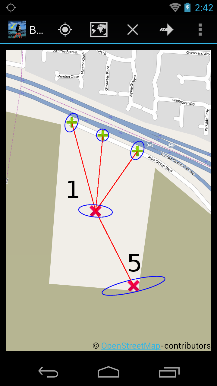
Accuracy (blue error ellipse in map):

Standard deviation is ver

Read more…

Point of Beginning

THE NEW POB


The new point of beginning for land surveys is orbiting the earth at 5,000 miles an hour 12 ½ thousand miles up in the stratosphere.  That’s correct and I suppose I owe my fellow professional land surveyors an apology for my participation in the changes we have been going through the last 20 years (see the POB cover article attached).  The fact of the matter is the PLS’s of this country have had our exclusive provenances invaded by all manor of non-surveyor professionals and others. 

Read more…

GIS & FEMA Mapping

There is a growing need for accurate land surveying data to be a fundamental requirement for government level geographic information systems. As an example for the USGS National flood inundation mapping science initiative a professional survey level data layer would be of great benefit to help determining exactly which structures in or out of the flood zones. Greetings my name is John W. Veatch. I am a land planner, a professional land development engineer, professional land surveyor, Florida Re

Read more…

Log into community to no longer see ads

Land Surveying Guides

Our Blog Sitemap


Explore Surveying Locally

USA Surveying Forums
Asia Surveying Forums
Africa Surveying Forums
Middle East Surveying Forums
European Surveying Forums
South American Surveying Forums
Oceania Surveying Forums
Surveying Equipment Support Forums
Search Survey Photos
Add Posts, Surveying Photos, Videos and Articles to the Surveyor Community
Add Stuff to Community


Latest in Surveyor Community

2025 Pacific Rim Geospatial Conference - Day 1 via GeoRadio- All Land Surveyor Podcasts in One

Check out these highlights from Day 1 of this year's awesome event!!!

01:00 - Victor Rasgado, Senior Surveyor at Stantec Consulting Services

12:09 - Heath Huovinen, Land Surveyor at The Independent Hawaii Surveyors   

27:05 -…

yesterday
Kiel Bailey is now a member of Land Surveyors United - Surveying Education Community
yesterday
Justin Farrow posted a discussion in Arizona Land Surveyors
Find and Connect with Arizona Land Surveyors on Facebook
Moved this from a previous page.
Ok, so you're a professional land surveyor in the state of Arizona and you've of course joined the group. But have you found and 'liked' your professional…
yesterday
The surveyor hub for Alabama Land Surveyors was featured
yesterday
The surveyor hub for Alabama Land Surveyors was featured
yesterday
The surveyor hub for Alabama Land Surveyors was featured
yesterday
The surveyor hub for Alabama Land Surveyors was featured
yesterday
Shay O'Sullivan is now a member of Land Surveyors United - Surveying Education Community
Wednesday
More…