SurveyingX is Mobile App For Land Surveyor
to accomplish surveying tasks, whether field or office, easily and effectively
Download the App for Android >>>>>> SurveyingX Pro
SurveyingX is Mobile App For Land Surveyor
to accomplish surveying tasks, whether field or office, easily and effectively
Download the App for Android >>>>>> SurveyingX Pro
https://www.aerotas.com/blog/how-to-unlock-a-dji-geo-zone
DJI’s Geospatial Environment Online (GEO) delineates where it is safe to fly, where flight may raise concerns, and where flight is restricted. DJI prohibits flight in GEO zones around airports, power plants, and prisons. DJI also temporarily prohibits flight around major stadium events, forest fires, or other emergency situations. Certain GEO zones don’t prohibit flight but do trigger warnings that inform users of potential risks. DJI GEO zones are not the same as FAA-controlled airspace; the two systems are entirely separate.
DJI made significant changes to its system for unlocking GEO zones that prohibit flight. Unlocking low-risk zones requires just a few taps or clicks, while high-risk zones require users to submit particular credentials to ensure compliance with local policies and regulations.

Clicking the “Unlock a Zone” button at dji.com/flysafe will now deliver a far different result.


Instead of bringing you to the custom or self unlock toggle screen, you are now kicked back to a log in screen and then into a whole new dashboard for managing your devices and their unlocking licenses.
(It is important to note that the old links - https://www.dji.com/flysafe/self-unlock and https://www.dji.com/flysafe/custom-unlock are still live. It is not certain when these links will be disabled, but DJI support says they will flip the switch soon.)
What’s more? Now you can unlock authorization zones directly in the app. You’ll need an active internet/cell connection, but so long as you update to the latest firmware, app, and GEO zone database versions, you will be able to unlock authorization zones on the fly. When in an authorization zone, and your flight status says “Cannot Take Off,” push both sticks down and in as if you were going to start the motors, and a pop up for the unlock will appear.
Unlocking authorization zones has gotten a lot easier in the app. But, you can still manually unlock zones through dji.com/flysafe ahead of your flights. It is important to note that you still need to submit a custom unlock for restricted zones (e.g., red zones).
DJI now requires quite a bit more verification of your information before actually allowing you to proceed to your actual unlocking request, which might sound like a headache to most.
Upon clicking “Unlock a Zone” at dji.com/flysafe, DJI kicks you back to a log in screen where you will need to log into your DJI account. While this seems unnecessarily redundant, this could be a welcomed measure. Our best guess is that it keeps individuals from requesting unlocking licenses inadvertently through the wrong DJI account and then not having their unlocking licenses appear on devices logged into a mismatched account.
After you’ve logged in, DJI takes you to a new dashboard. To proceed to your unlocking license requests, DJI first routes you to some identity authentication/verification steps, putting a new speed bump in the process. Once you complete the verification steps, you will be able to access the dashboard. It is important to note that you should only have to authenticate your email and phone number the first time you set up your dashboard (which is nice!).
The new dashboard has some welcomed new features, including the ability to “add a device” (drone) and pilots to your account via their flight controller serial numbers/models and DJI accounts, respectively. These features aim to organize fleets of aircraft, whether across a company or a personal fleet and potentially across multiple DJI accounts.
The ability to save pilot and aircraft information is a welcomed one. Seemingly gone are the days of having to recall or write down your “flight controller serial number” somewhere to use it for unlocking. DJI’s new dashboard will save the FCSN within the device identity, so you’ll only have to input it once for each device you add to your dashboard.
After you have your dashboard set up, you will be able to proceed to your unlocking requests.

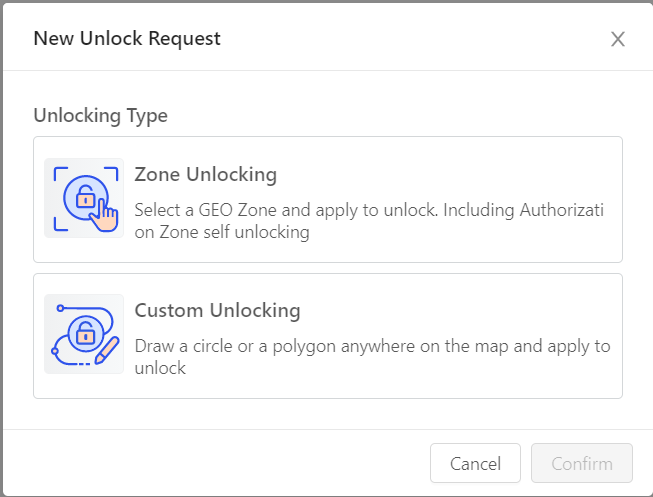
“Zone Unlocking” is like your typical “self unlock” request. If you select this option, you can unlock authorization zones the same way you did before.
“Custom Unlocking” allows you to define a specific area within a Geofenced zone for your flight utilizing a polygon or radius that you draw yourself on the map provided. Each custom unlocking request requires you to attach some documentation to proceed with the request. The required documentation may change depending on the type of zone. Authorization zones typically need less official documentation than restricted zones to unlock.
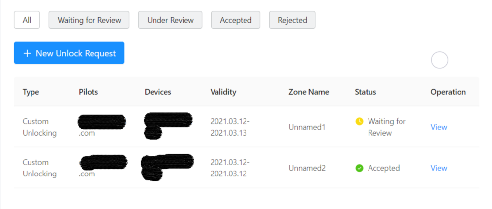
Once you have submitted your request, DJI will send you back to the dashboard screen where DJI displays your pending and approved flights.

For a complete in-depth step by step walkthrough of unlocking DJI GEO zones using DJI’s new dashboard go to https://www.aerotas.com/unlocking-dji-nofly-zones
Polosoft technologies, a growing company in the field of GIS web and mobile application development with a highly experienced team. Recently, we have developed an android survey application (GIS Surveyor) for surveyors and GIS professionals.
The application will be most useful with lots of features for land surveying, agricultural, farming, forestry, timber inventories, site surveying, environmental systems, and highway road surveying.
Top 5 Benefits of the GIS surveyor application:
- Possibility to view multiple layers including points, lines and polygons at the same time.
- Possibility to group data into survey layers - each survey layer may have a default set of attributes.
- Four methods of data collection are supported, GPS/GNSS location, map cursor location, GIS Tracker, point projection using angle and distance.
- Direct export to Dropbox, Google Drive at anywhere location.
- Import point, line and polygon features into layer from CSV, KML or GeoJSON file.
Download Required on Android OS 4.4 and up.
We will be adding more technical features in the application in the coming few days. Go through this Playstore link to download the GIS Surveyor application.
Use the forums inside this module to Introduce Yourself inside the dedicated Hub Forum for Your Location --->
Simply click the other tab, find your location and find the Add Discussion Button which looks like this:
Tell us something we may not know about Land Surveying in your part of the world. We look forward to meeting you!
Our community is a unique place where the juniors of surveying learn from the seniors and vice versa. We bridge the knowledge gap in the field with shared experience. With our ever-growing need to adapt and utilize technology both in the field and in the office, Land Surveyors United network is your place to cultivate new talents, find and share Surveying Job opportunities, share your present and past accomplishments, and foster long-lasting relationships with student surveyors and other land surveyors around the world. Bookmark this page and when you have an idea or something interesting and useful to pass along to your colleagues and prospects around the globe, share it in a post or a photo.
▶️. Tell us what we should build NEXT for the community.
🧙♂️. Become a Mentor for those new to surveying
Meet up with other surveyors insideVirtual Chat for the community.
🎙️ Listen to all of the Surveyor Podcasts in one place.
💥 Find the perfect Surveying Job of your dreams
Generate a Resume in seconds
💪. Post your available positions for Surveyors Seeking Employment.
🔍️. Find deals and specials on Survey Equipment from the marketplace.
📍. List your company inside the Survey Company Directory.
🌐. Contribute to surveying knowledge Locally inside your local hub community.
🖼️. Share images from the field and Photos of Surveying for the community.
🎯. Find targeted support for your Surveying Equipment from other users.
📺️. Learn something new everyday from Surveying Tutorials curated by the community.
🧰. Customize SurveyorSpreadsheet tools shared by the community.
⛓️. Add a badge to your website and Show your support for the community.
🗺️. Add a point to the new Land Surveyor Atlas and find or post jobs.
📄. Publish an article or republish an outdated document.
👽️. Learn how to use Artificial Intelligence in AI for Surveyors Hub.
📆 Increase turnout by sharing Local Surveying Events with the community.
📃. Over 16 years of community curated Surveying Related Documents.
📜. Submit a term to the Land Surveyor Dictionary for the future.