This group is for Land Surveyors United members who use Leica Geosystems Surveying Instruments in the field. This group is for discussions and tutorials related to Leica user. Land Surveyors United is not directly affiliated with Leica and all logos and imagery are copyright of their respective owners.
Hello gents, I have the following problem with LGO v5: I'm trying to export dxf/dwg files but i can't export eny atributes besides the default "elevation" and "point ID". What i need is to organize different attributes by layers(ex: elevation in one layer, codes in another layer, points with 2D/3D coord in other layers), so that i could precess data easier in autocad. Is there any way that i can get it done through LGO settings or i have to right a script for this? (i'm sure that it can be done because i allready saw someone doing this).
I also didn't find the option where i can import a .dxf template with the layer and block that i need for export.
I would be very grateful if you can help me out.
You need to be a member of Land Surveyors United - Surveying Education Community to add thoughts!
Replies
Have you tried this
Export mode
This option offers the choice between two export modes:
Graphic:
This mode is quick and reliable. It is useful if you want to export a CATDrawing to AutoCAD and print it without modifying it.
Semantic:
The exported file can be modified.
The Semantic mode offers the following options:
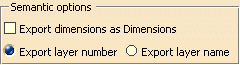
Export dimensions as Dimensions:
If you select this check box, linear, angular and circular dimensions are exported as true dimensions (with a default dimension style).
Default dimension style entails that most graphic attributes
(such as color, display format of the dimension value, type of arrow, space...) of the dimensions are lost.
With the exception the None layer, each V5 layer is defined by three data:
Its number,
An optional name,
An optional comment.
In AutoCAD applications, layers are defined by:
a name,
a status,
some graphical attributes.
You can choose how you want to export layer number:
Export layer number:
Each V5 layer is exported with an AutoCad layer name that is the number of the V5 layer
Export layer name:
If the V5 layer name is an empty string, the V5 number is exported (whenever the AutoCAD export version chosen).
If AutoCAD R12, R13 or R14 is selected as the export version, then only the first 26 characters are exported.
The only characters exported are:
letters (from 'a' to 'b' and from 'A' to 'Z') all converted in upper case,
digits (from '0' to '9')
and the following special characters: the hyphen '-' and the underscore '_'.
All others characters are exported as underscore '_'.
If AutoCAD 2000 is selected as the export version, then only the first 255 characters are exported, with the same constraint about characters as above,
except that lower case letters are not changed to uppercase letters.