Endangered Art of Chaining Hub is for, Land Surveyors United members to discuss the Gunter's Chain and the endangered art of chaining in the land surveying profession. Share your best experiences and tips for chaining in land surveying.
Gunter's chain (also known as Gunter’s measurement) is a distance measuring device used for surveying. It was designed and introduced in 1620 by English clergyman and mathematician Edmund Gunter (1581–1626). It enabled plots of land to be accurately surveyed and plotted, for legal and commercial purposes. Gunter developed an actual measuring chain of 100 links. These, the chain and the link, became statutory measures in England and subsequently the British Empire.History of Angles and Measurements
Recently I was looking into the history of angles and measurements and found a terrific timeline on google that I wanted to share. You can find the timeline here in search. I also found a great book which I have embedded below. Open publication - Free publishing
Read more…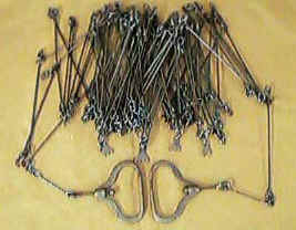
Thoughts
In the early 1800's two "King's Surveyors" were found dragging a chain through the Maine forests. They were asked "Why are you pulling that chain through our forest?" "Have you ever tried pushing a chain?" was the answer.
David C. Garcelon
Did you know that the length of a Cricket Pitch is 22 yards (66 feet) long (the distance down the center of the cricket field between the wickets). Another irony of the English influence on the length of the chain !!
David c. Garcelon
I believe it was Professor J.B. Johnson who pointed out that if you had a 100 link chain with three loops connecting each link (808 wear surfaces) that if you had 0.005 inches of wear on each wear surface your chain would be measuring 4 inches short for each full chain measured; i.e. actual distance of 66 feet would measure 65.66 feet (99.5 links) long. That is why the better chains had the ability to be adjusted for length at each handle. It is also why John Grumman developed the "Grumman Patent "Chain" for, believe it or not, surveying in cities.
David C. Garcelon
Chain surveying was taught even in books on Geodesy prior to 1900.
The texts that taught it in the 18th and 19th centuries are too many to mention. John Whitelaw Jr's1902 text on surveying begins with "Chapter 1-Chain Surveying" and is 59 pages long with many illustrations.
I wonder, Randall, when you talk about "throwing a Chain" if you mean "Throwing a chain tape".. In my early days I did a lot of forestland surveys and we would use a 66 foot (1 chain) band tape
with babbitt metal at every foot mark..we would call it a "chain tape" because of its length or a "drag tape" because we would take it off of its reel and drag it along the ground between measurements (so we wouldn't have to "Throw" it or wind it back onto the reel).
David C. Garcelon
He came from setting up range poles out in front of us to check on our most recent measurements. The traverse legs were measured with a 30 meter steel tape using chaining pins. The crew reported distance and the recorder reported the last angle I turned. Indian Territory said, "That distance is wrong. You dropped a pin." They asked how he knew. His response was that he stepped off the distance and knew what it ought to be.
They made the mistake of telling him he could not know they were wrong by stepping off the distance. The end result is that we all got to practice chaining that traverse leg and were sent back to chain it again when we did not match each other well enough to suit him.
I learned a lot of good lessons that day. I was 19 years old, cocky, and bullet proof. But I learned that old man was serious and correct when he made bold statements. He taught me exactly what it meant to bet my life on the accuracy of my measurements.