- Community
- Community Blog
- Surveyor Community Blog
Featured Posts (389)
Sort by
Long time since I have been on-line here. I salute LSU on growing a large base, and I have witnessed a growth in the content and number of members. This is a great all encomplassing surveying site. Have been working on a blog site, and a learning site that for land surveyors and GIS folks "who want to know about land surveying, GIS and people who I have been able to video. Lot's of short videos,interviews, tutorials, articles and papers on the historyl of Texas Land (Darrell Shine's collection)
There is a growing need for accurate land surveying data to be a fundamental requirement for government level geographic information systems. As an example for the USGS National flood inundation mapping science initiative a professional survey level data layer would be of great benefit to help determining exactly which structures in or out of the flood zones. Greetings my name is John W. Veatch. I am a land planner, a professional land development engineer, professional land surveyor, Florida Re
Following examples are calculated with BestTachySpot.
You may have experienced this before. You are defining a new station and all points with known coordinates are more or less in the same direction. Be careful in this situation.
The situation explained with an example:
Resection on point 1 with observations to known backsight points on the road north of the site (green in following figure). Goal is to find the coordinates of point 5.
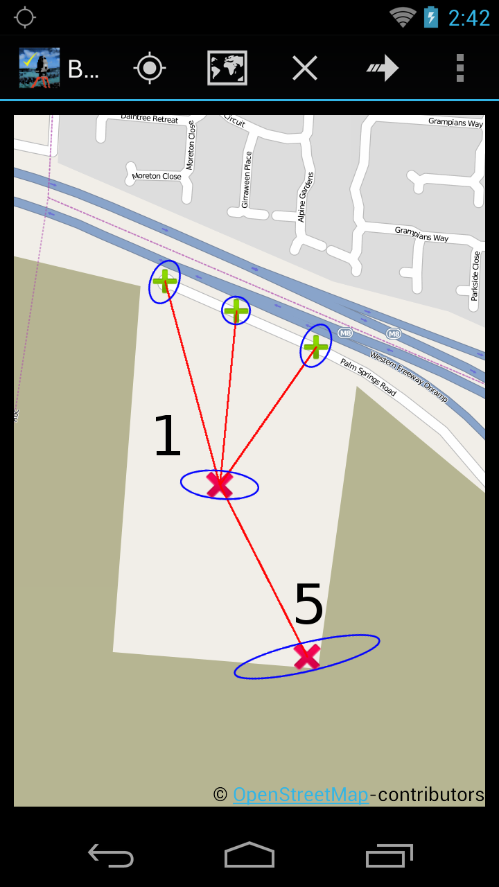

Accuracy (blue error ellipse in map):
Standard deviation is ver
Why is "traverse 3" a good solution and "traverse 1" not? What is the difference in accuracy and reliability?
Following examples are calculated with BestNetwork.
Traverse is a method to establish control networks. Traverse networks involve placing survey stations along a line and then using the previously surveyed points with known coordinates as a base for observing the next point.
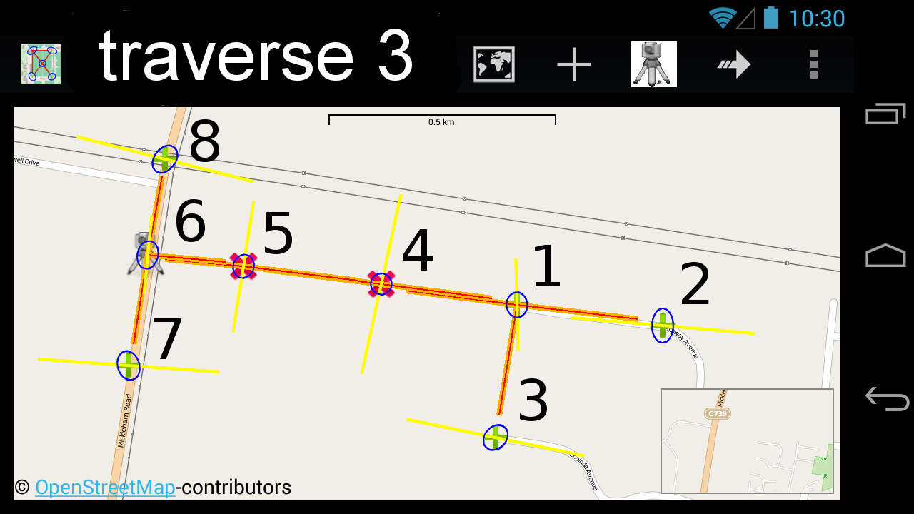
Traverse 3 explained:
- 2 new points with unknown coordinates are marked in red (points 4, 5).
- Existing points wit
Over 75 recipes to help you automate geoprocessing
tasks, create solutions, and solve problems
for ArcGIS with Python
In the spirit of welcoming the new year, we are liquidating many items from the store to make room for new stuff! My son Justin has been helping me get the store in order and putting a fresh face on ePalmetto. As you can see in our recent post for January Survey equipment Liquidation, there are many items on sale that you might like to grab while you can..
Survey Equipment Inventory Sale
Here is a short list of equipment we are selling from the closet:
(3) B-1 Levels
(1)SDR33 Data Collector
(1)Sa
You Are the Missing Link
There is (as predicted) a LOT of talk surrounding the need for land surveyors to attend all sorts of seminars on Social Networking and how social media is changing the landscape for PLS and the ways in which business is changing worldwide. I know, I know. Groan-Sigh-Hiss. Sounds downright painful for those of us that consider the internet to be free and fun. The fact of the matter is, those who tell you this sort of stuff have made it a business to recruit you to do suc
It’s All Greek to Me
At one time or another you may have heard the terms “surveyor,” or “land survey,” or “land surveying.” You might have an idea of what a surveyor is–the most common image people imagine is of someone standing in the middle of a road, blocking traffic, with a funny looking “camera” on top of a large tripod. To be certain, that person is a surveyor, and that funny “camera” is what is known as a Total Station. A Total Station is a precision instrument used to measure angles a
Not that any of you are dummies, but these dummy books sure come in handy when you're in a pinch. Feel free to search them right here or download. Enjoy surveyors!
GPS for Dummies
GIS for Dummies
Check your network design with BestNetwork.
Spread Sheet for vertical curve and Super Elevation Distribution Method for Surveyors
Total files 7 at bottom of post. Download them and enjoy the work
crestvc.xlsformula%20for%20vertical%20curve%2020%20m.xlsformula%20for%20vertical%20curve%2025%20m.xlsformula%20for%20vertical%20curve%28revised%29.xlsformula%20for%20vertical%20curve.xlsSuper%20elevation%20Hashmi.xlsSuperelevation%20distribution%20formula.xls
"If life were perfect, we would all paint, we would all play an instrument, we would all dance. But because we know that life isn’t always perfect, we have to have dance, we have to have music, to remind us how good life can be." – Suzanne Farrell
It seems reasonable to think that removing the huge pecan tree east of the ProFlex500 base station antenna would influence the OPUS results. But my first OPUS report following removal of the tree was included in the current average NAD83(2011) position. This remains a work in progress. Over time there will be more OPUS sessions. Each time I will decide whether to include it in the average or begin again.
The OPUS reports, raw data files, and more photos are available on my projects ftp site.
Professional Land Surveyors of the World UNITE!
As anticipated, the second annual International Surveyors Week begins now, once again uniting professional land surveyors on a global scale. During this week you will be accomplishing two important issues for land surveyors:
1) Educating the public regarding the importance of professional land surveyors to society and...
2) Cultivating a real global community for land surveyors to grow and thrive within. International Surveyors Week 2013 is an even
Finally an Adventure novel featuring a Land Surveyor and his son. Check it out at Amazon.com Barnes and Nobel. E-book is out now and paper copy coming in weeks. A sequel is in the works. See also tlacorte.wordpress.com and a big thank you to all in the surveying community for supporting the book so far. Nothing but great reviews for "6 Miles With Courage"
GPS SURVEY
The Global Positioning System (GPS) is a satellite-based positioning system made up of a network of 24 satellites placed into orbit by the U.S. Department of Defense. GPS satellites circle the earth twice a day in a very precise orbit and transmit signal information to earth. GPS receivers take this information and use triangulation to calculate the exact position of them. GPS receiver compares the time a signal was transmitted by a satellite with the time it was received. The time di
Log into community to no longer see ads
Land Surveying Guides
Our Blog Sitemap
Explore Surveying Locally
USA Surveying Forums
United States Surveyors
- Arizona
- Alabama
- Alaska
- Arkansas
- California
- Connecticut
- Delaware
- Florida
- Georgia
- Hawaii
- Illinois
- Indiana
- Iowa
- Kansas
- Kentucky
- Maine
- Maryland
- Massachusetts
- Michigan
- Minnesota
- Missouri
- Montana
- Nebraska
- Nevada
- New Hampshire
- New York
- North Carolina
- North Dakota
- New Mexico
- Oklahoma
- Ohio
- Oregon
- Pennsylvania
- Rhode Island
- South Carolina
- South Dakota
- Texas
- Utah
- Vermont
- Virginia
- Washington
- Wyoming
- Wisconsin
- West Virginia
- USA Surveying Events
Asia Surveying Forums
Africa Surveying Forums
Middle East Surveying Forums
European Surveying Forums
South American Surveying Forums
Oceania Surveying Forums
Oceania Land Surveyors
Surveying Equipment Support Forums
Choose Your Equipment Type
Search Survey Photos
Search Surveying Photos by Tag
Add Posts, Surveying Photos, Videos and Articles to the Surveyor Community
Add Stuff to Community
Latest in Surveyor Community
May 17, 2024 from 5:00am to 5:00pm
Beckley Raleigh County Convention Center